As South Africans we definitely don’t have a shortage of bragging rights, especially when it comes to scenic routes and epic views. One of our country’s most awe-inspiring features is our vast amount and variety of mountain passes. To pick a few favourites is next to impossible, but we gave it a try and decided to share a taste of each of them with you!
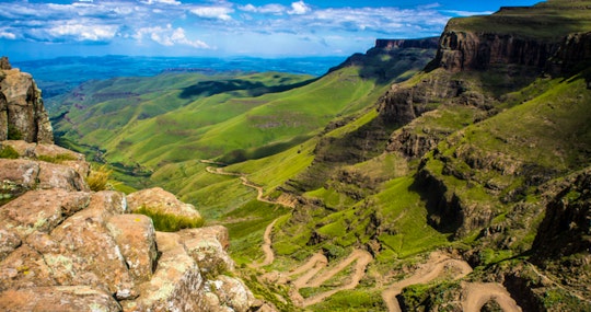
Sani Pass
Range: Drakensberg Mountains
Elevation: 2,876 m
Fun fact: Highest pass in South Africa
Sights: The Highest Pub in Africa, Local Basotho’s carting food and goods up the pass by horse and mule, various waterfalls
Long Tom Pass
Length: 22,2 km
Elevation: 2150 m
Fun Fact: Most famous pass in Mpumalanga and alternative route for the waggoners of the 1800s
Sights: The Long Tom Cannon, Visierkerf (Gunsight Notch), Whisky Creek Waterfall, Die Duiwel se Preekstoel (The Devil’s Pulpit)
Matroosberg Pass
Elevation: 2,249 m
Fun Fact: One of the highest peaks in the Western Cape and South Africa.
Sights: 4×4 trails, snow, camping, extreme sports
Naude’s Neck Pass
Range: Southern Drakensberg Mountains
Elevation: 2587 m
Fun Fact: Second highest pass in South Africa
Sights: Tenahead Mountain Lodge, Mooidraai Lookout Point, National Monuments Council plaque
Bain’s Kloof Pass
Length: approximately 28 km
Elevation: 594 m
Fun fact: First pass ever built by the father of SA passes, Andrew Geddes Bain
Sights: Paradise Valley rock pools, Tweede Tol camping and rock pools, Limietberg Hiking Trail, Pilkington Bridge, Bell Rocks and Dacres Pulpit
Nuwekloof Pass (Baviaanskloof Pass)
Range: Baviaanskloof Mountains
Fun Fact: It is a proclaimed World Heritage Site
Sights: Open caves and tree house accommodation, Vero’s Restaurant, Studtis Olive Estate
Outeniqua Pass
Range: Outeniqua Mountains
Elevation: 795 m
Fun Fact: Built by Italian prisoners of the Second World War
Sights: Epic views over George and the Indian Ocean in the background, cascading waterfalls, several rest stops, Hops Valley Farm Stall
Swartberg Pass
Range: Swartberg Mountains
Elevation: 1575 m
Fun Fact: Status as a national monument and rubicon of gravel road passes
Sights: Eerste en Tweede Water, picnic sites, Malvadraai swimming spot, Die Stalletjie (Small Stall), Witdraai (White Corner), Fonteintjie (Small Fountain), Skelmdraai (Devious Corner) and Die Top
Kaapsehoop Pass
Elevation: 1653 m
Fun fact: Rumoured to be haunted by ghosts of old women and children and phantom gold prospectors
Sights: Kaapsehoop village and wild horses, views of The Valley of Death, Battery Creek
Tradouw Pass
Elevation: 351 m
Fun fact: Considered by many road builders as Bain’s best pass in terms of technical ingenuity
Sights: Die Drupkelder (The Dripping Cellar), Suurbraak, views down into the gorge of the Tradouw River with its rock pools and waterfalls, picnic spots
Eland’s Pass (Gamkaskloof Pass)
Elevation: 973 m
Fun fact: Paradoxically nicknamed Die Hel, UNESCO World Heritage site, and about 100 people lived in Die Hel at its most populous time
Sights: Oom Koos se Klip, Die Leer, Grootkloof waterfalls, Annetjie’s restaurant
Gifberg Pass
Barkly Pass
Location: Between Elliot and Barkly East, Eastern Cape
Range: Drakensberg Mountains
Length: 11 km
Elevation: 2018 m
Terrain: Tar
Fun fact: Only tarred pass of the Big 8 Eastern Cape passes
Sights: Mountain Shadows Hotel, Skilpad Rock, Castle Rock, snow, sandstone rock formations, original rock art
Attakwas Pass
Location: Between Mossel Bay and Oudtshoorn, Western Cape
Range: Attakwas and Outeniqua Mountains
Length: 22,3 km
Elevation: 846 m
Terrain: Gravel (4×4’s only)
Fun fact: Over 300 years old and first used by elephants
Sights: River crossing, Bonniedale Farm, magnificent fynbos, Attakwas Hiking Trail with its rock pools
Abel Erasmus Pass
Location: Between the towns of Ohrigstad and Tzaneen, Limpopo
Range: Drakensberg Mountains
Length: 9,8 km
Elevation: 1011 m
Terrain: Tar
Fun fact: Known as the gateway to the Panorama Route
Sights: Kadishi Tufa Waterfall (the highest tufa waterfall in Africa), Blyde River Canyon, Olifantsrivier
![]()
No proper South African roadtrip is complete without a drive along one of our scenic passes! And to top it all off, each of these passes offers sights and hidden delights that make them sought-after destinations in their own right. Let us know which one is your favourite and why!
Feature image: “zuidafrika-142” by Vaiz Ha (Flickr)